


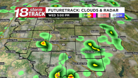


A few showers have popped up this afternoon, including a few thunderstorms. Most of the activity has been south of US-10, though a couple showers have popped up in Eau Claire and Clark County and will continue to move east to west (yes, opposite of normal storm motion) until they fizzle out around or slightly after sunset.

These showers have a small chance of producing measurable rain, and it needs to specifically rain at the airport in order to officially end Eau Claire's dry streak that will be 11 days if it does stay dry today.
Eau Claire hit a high of 86° this afternoon, and dew points even rose into the mid/upper 50s. That's high enough to begin to feel a bit of moisture in the air, though not to the point where it feels humid.

Tomorrow will have similar to even a slightly higher chance for pop-up showers/storms than today's, though still expected to be in the pop-up/isolated category mainly in the afternoon and evening.
The best chance for rain and storms will come on Thursday as an organized low pressure system moves through the Upper Midwest. That comes with a chance for severe storms.

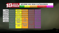
Most of Western Wisconsin is currently in the Storm Prediction Center's level 3 risk for severe weather, meaning that numerous severe storms are possible.

The technical definition of a level 3 risk is having at least a 30% chance of severe weather within 25 miles of any point in that risk area. We are also in a hatched area (black slashes on the probability map), meaning there's at least a 10% chance of significant severe weather. That's defined as having EF-2+ tornadoes, 75+ mph gusts, and/or 2"+ hail within 25 miles of any one spot.
This does mean that the probability of NOT having severe weather near you is still higher than it happening, but this is a fairly high risk for the Upper Midwest since severe weather by its very nature affects only very localized areas within the much larger risk area.

Historically, Level 3 risks have at least a few areas within the level 3 area with multiple severe storms, and they tend to be a bit more persistent in strength with isolated areas being particularly intense.
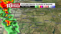
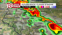
One thing that could limit storms is if clouds and especially rain linger midday into early Thursday afternoon. If that happens, there won't be as much energy from humidity and heat especially for storms to become severe. However, this round of FutureTrack shows sunshine most of Thursday afternoon. See maps below.

Another thing we'll be tracking is the speed of the cold front. If it moves faster than currently expected, then the strongest storms won't form until they are east of the Chippewa Valley. If it's slower than expected, then storms will move through later in the evening, and might not be as strong if they arrive after sunset.
Now, let's track the timing.

The strong storms ahead of the cold front will approach Western Wisconsin between 3 and 4 PM. They will be in a line, however there could be individual supercells (defined as a rotating thunderstorm) all lined up. If that happens, the tornado threat will be higher.

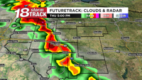
It looks most likely for the strong to severe storms to move through Western Wisconsin between 4 and 6 PM, with a line of storms with embedded supercells possible.

Storms will still be strong until this main line exits between 7 and 10 PM, with a few isolated showers and storms continuing overnight even as the severe threat wanes.
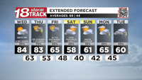
Clouds, drizzle, and a few showers are still possible on Friday as much cooler air moves into Western Wisconsin. Some places won't even hit 60° in the afternoons Friday through Sunday. Lingering showers could continue into Saturday morning before drying up.
Cooler than average temperatures will continue into early next week along with more chances for showers and thunderstorms.


